Fidaz - Bargis - Fidaz
moyen
Trail running
Naviguer
Naviguer
Télécharge cette visite sur ton portable
Carte
Fidaz - Bargis - Fidaz
moyen
Trail running
6,69 km
Scanner le code QR et commencer la navigation dans l'application bergfex
QR Code
Randonnée & tracking
Téléchargement pour iOS
Téléchargement pour Android

Fidaz - Bargis - Fidaz

Distance
6,69 km
Durée
01:25 h
Ascension
348 m
Altitude
1 186 - 1 548 m
Téléchargement de la piste
Carte
Fidaz - Bargis - Fidaz
moyen
Trail running
6,69 km

You start at the parking lot in Fidaz. If you want to arrive by bus, there is a bus stop nearby. This loop to the imposing castle ruins of Belmont is short and crisp. You run over a rocky and rooty trail,...


Description

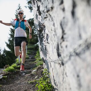
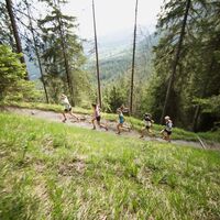
You start at the parking lot in Fidaz. If you want to arrive by bus, there is a bus stop nearby. This loop to the imposing castle ruins of Belmont is short and crisp. You run over a rocky and rooty trail, partly steeply uphill. The trees provide you with shade and cool the air, while your breaths become shorter. On boardwalks along rocky walls, you will wind your way up into the high valley of Bragis. Now your path widens and runs comfortably downhill, before you climb the last meters over a path partly cut into the mountain to the ruins of Belmont Castle. Trot through the fairytale forest back to your starting point.

Parcours
Fidaz
(1 188 m)
Quartier
0,1 km
Bargis
(1 543 m)
Couloir/terrain
2,9 km
Bargis
(1 551 m)
Restaurant
3,0 km
Fidaz
(1 188 m)
Quartier
6,6 km
Parcours
Carte
Fidaz - Bargis - Fidaz
moyen
Trail running
6,69 km
Fidaz
(1 188 m)
Quartier
0,1 km
Bargis
(1 543 m)
Couloir/terrain
2,9 km
Bargis
(1 551 m)
Restaurant
3,0 km
Fidaz
(1 188 m)
Quartier
6,6 km
Description

Enchanting cool forests, sun-drenched high valleys and the impressive ruins of Belmont Castle reward you for a short and steep climb. The panorama that opens up to you here as far as Domleschg is sensational.

Technique
n.d.
Endurance
4 / 6
Paysage
5 / 6
Expérience
5 / 6
Meilleure période de l'année
Jan
Fév
Mar
Avr
Mai
Jun
Jul
Aoû
Sep
Oct
Nov
Déc
Auteur
Fourni par Flims Laax
La visite Fidaz - Bargis - Fidaz est fournie par outdooractive.com.
Logo
Partager la visite
Carte
Fidaz - Bargis - Fidaz
moyen
Trail running
6,69 km
Erreur
Une erreur s'est produite. Veuillez réessayer.
Consignes de sécurité

You start at the parking lot in Fidaz. If you want to arrive by bus, there is a bus stop in the immediate vicinity. This loop to the imposing castle ruins of Belmont is short and crisp. You run over a rocky and rooty trail, partly steeply uphill. The trees provide you with shade and cool the air, while your breaths become shorter. On boardwalks along rocky walls, you will wind your way up into the high valley of Bragi. Now your path widens and runs comfortably downhill, before you climb the last meters over a path partly cut into the mountain to the ruins of Belmont Castle. Trot through the fairytale forest back to your starting point.

Informations sur l'arrivée
Arrivée

By car A13 freeway from Zurich, exit 18 Flims.

Transports en commun

By PostBus to Stop: Fidaz via Flims Dorf Post

Parking

12 parking spaces at the cable car Fidaz

Infos complémentaires & conseils
Informations supplémentaires

Gästeinformation Flims Laax Falera

Via Nova 62

CH-7017 Flims

Tel: +41 (0)81 920 92 00

E-Mail: info@flimslaax.com

Internet: www.flimslaax.com

Pas encore d'évaluation
Écrire une évaluation

Les évaluations aident les autres utilisateurs à choisir leur prochaine aventure. Veuillez évaluer uniquement l'excursion, pas la météo ni votre casse-croûte.

Choisissez une des étoiles pour évaluer la visite
Mauvaise visite
Tour faible
Tour moyen
Bonne visite
Excellente visite
bergfex logoObtenez un aperçuToujours en direct avec plus de 9.500 webcams. En tant qu'utilisateur Pro, vous pouvez désormais voir les webcams correspondantes à de nombreuses randonnées dans l'application de randonnées de bergfex. Vous pouvez ainsi voir directement les conditions actuelles.
Randonnée et suivi

Randonnée et suivi

télécharger pour iOStélécharger pour Android
Randonnée et suivi
Plus de 550.000 propositions de circuits, des cartes détaillées et un planificateur d'itinéraire intuitif font de cette application un must pour tous les passionnés de nature.
Randonnée et suivi